A historic storm brings widespread coastal flooding to western Alaska
Unusually high sea surface temperatures played an important role in the late-season storm's ferocity, a forecaster said.

The remnants of Typhoon Merbok pummeled coastal settlements in western Alaska on Saturday, bringing high winds and the highest sea levels recorded in some Bering Sea communities in half a century.
Alaska Gov. Mike Dunleavy declared a disaster on Saturday morning, and the state formed an emergency operations center. No fatalities or injuries have been reported.
As the massive storm — so big, it will take three hours for the sun to set over it — moved up the Bering Strait, coastal flood and high wind warnings went in effect for Alaska’s West Coast and Western Arctic Coast.
It is unusual for a storm to intensify so quickly at high latitudes this time of year, and “supercharged sea surface temperatures” played an unmistakable role in driving that, climatologist Brian Brettschneider said on Twitter.
While the storm was well-predicted by weather models days in advance, state and federal agencies were still slow to respond, Rick Thoman, a climate specialist for the Alaska Center for Climate Assessment and Policy, said on Twitter.
“It doesn’t have to be this way,” he wrote.
It was also difficult to forecast the level of flooding expected in advance of a storm like this, because long stretches of the coastline have no ocean level gauges, he said.
https://twitter.com/AlaskaWx/status/1571286556002127872
In Nome, the water reached 10.52 feet — higher than storms in 2011 and 2004, and a height unrivaled since waters rose to approximately 12 feet during the 1974 storm.
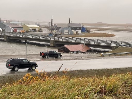
Front Street was inundated, and water surged over the causeway at the Port of Nome. A home was pushed under the Snake River Bridge.
Well front street is basically gone on the east side of town. #Nome #BeringSeaStorm pic.twitter.com/WHlU5z8PgR
— A_Tangle ☮️🇵🇷 (@A_Tangle) September 17, 2022
Flights to Nome and Kotzebue were canceled on Saturday morning.
The airport in Unalakleet was flooded by 8 am.
Images from the FAA airport webcam in Unalakleet. One image shows a normal day, the other shows water inundating the area around the airport as of 8am this morning. Water levels will continue to rise another foot by this afternoon. #akwx pic.twitter.com/0tVjXy3dLv
— NWS Fairbanks (@NWSFairbanks) September 17, 2022
Some homes floated off their foundations and fuel tanks tipped over in Golovin, which lost power. Families in Hooper Bay were evacuated.
The community of Newtok was completely flooded, and Patrick LeMay — who is leading the community’s relocation to a new site — estimated that 100 feet of shoreline vanished in this storm.
The storm has affected communities as far south as Bethel.