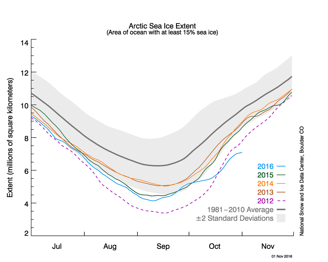
Arctic sea ice growth slowed in October, setting another low-extent record
It’s been a long, strange year for Arctic sea ice.
It began with a storm that brought unusually warm temperatures — about 50 degrees Fahrenheit above average — to the North Pole. January saw the lowest extent of ice ever recorded for that month. Then so did February. And April. And May. And June.
In March, when the ice reached its maximum extent for the year, it was the lowest on record.
The pace of melting surprised even scientists long-accustomed to the ice’s decline — which seemed on pace to plunge below 2012’s record low.
[Here’s how much of the Arctic you’re personally responsible for melting]
But then the pace of melting slowed, and by September, instead of talking about a new record, ice observers were wondering whether it would be the second-lowest or only the third. (It wound up tied for second).
Without the superlatives, attention faltered. And so did the ice’s regrowth. After a quick growth spurt, it stalled, and by last month, it was back in record-setting territory, with the lowest October extent ever recorded.

One long-term reason why ice has declined, freshly highlighted in a series of visualizations released by NASA late last month, is that the ice that has formed is younger and thinner.
Thick, old multi-year ice served as a “bulwark” against melting, said Walt Meier, a sea ice researcher at NASA’s Goddard Space Flight Center. “ But this older ice is becoming weaker because there’s less of it and the remaining old ice is more broken up and thinner, so that bulwark is not as good as it used to be.”
A more immediate reason why ice grew so slowly in October was that ocean surface temperatures in seas along the margins of the Arctic Ocean were warmer than usual—in part because they’d spent less time covered by ice and therefore more time absorbing sunlight, according to analysis from the National Snow and Ice Data Center. The heat had begun to ebb by the end of October, but temperatures were still above average.
Meanwhile, a low pressure system over the Bering Sea and high pressure over Scandinavia both brought southerly winds to the Arctic, keeping air temperatures warmer than usual.
Alaska’s northernmost town, Barrow (soon to be Utqiaġvik) set several warmth records on the way to its warmest October on record, while other places in Arctic Alaska saw warmth records, too. The Norwegian Arctic Archipelago of Svalbard also had its warmest October on record, as well as its wettest, reported The Independent Barents Observer.
Meanwhile both Barrow and Longyearbyen, Svalbard’s largest settlement, recorded their warmest ever October temperature, as did parts of Iceland, according to the Iceland Monitor.
Read more:
Here’s how much of the Arctic you’re personally responsible for melting
Barrow posts record-warm October, continuing pattern associated with low sea ice