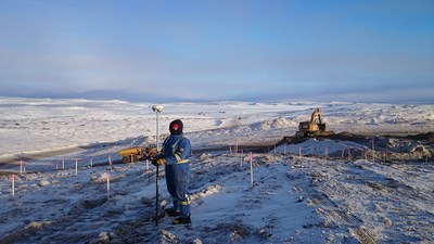
Inukshuk Geomatics Celebrating 20-year partnership with Inuvialuit Development Corporation
INUVIK, NT, Feb. 16, 2021 /CNW/ – Building on our significant experience operating in the north, Challenger Geomatics has formed strong relationships with many local Indigenous partners, and we are pleased to be celebrating, alongside our Inuvialuit partners, this important milestone.
Inukshuk Geomatics is an Indigenous-owned company providing professional geomatics services in the Inuvialuit Settlement Region (ISR) of the Northwest Territories which includes the communities of Inuvik and Tuktoyaktuk. The company is 51% owned by Inuvialuit Development Corporation (IDC). Challenger Geomatics Ltd. owns the remaining 49%.
In the year 2000, there was significant interest in accessing oil and gas resources in the Canadian Arctic. Challenger’s client, PetroCanada, had a significant project in the Mackenzie Delta and wanted to ensure Inuvialuit participation. Challenger eventually negotiated an agreement to found this new company at the end of that year.
“[IDC] is pleased to celebrate the accomplishment of over 20 years in partnership as Inukshuk Geomatics with Challenger, which has continually demonstrated its commitment to the Region, working with and alongside local people and business and offering skills capacity, while the completed work significantly contributes to many of our important infrastructure projects.”
Patrick Gruben, IDC Chair
One of the most significant infrastructure developments in recent years has been the construction of the Inuvik-Tuktoyaktuk Highway. For E. Grubens Transport and Inukshuk Geomatics, building the northern 60 km had its fair share of challenges. Over 4 years, Inukshuk Geomatics provided survey support for the highway’s design, identified gravel pit locations and access, provided construction survey support, completed the largest legal survey executed on Canada Lands in 2017, and conducted the final as-built survey.
“I’ve had the good fortune of working with the Inuvialuit in the ISR for the last 15 years. A true highlight was two winters that I spent scouting the Inuvik to Tuktoyaktuk highway prior to construction. My Inuvialuit guides had an intimate knowledge of the landscape that was truly impressive. I’ll always remember the long days on snow machine in beautiful country.”
Paul Burbidge, President and CEO of Challenger Geomatics
Ensuring local communities can fully participate in geomatics activities on their land has always been a high priority for Challenger. Technical staff have delivered surveying and geomatics training in these communities and partnered with local colleges.
“IDC expects Inukshuk Geomatics will only continue to contribute and advance in our partnered work, which is a critical basis of the road upgrading, reclamation and development projects needed to build our communities,” explained Patrick Gruben.
Inukshuk Geomatics along with Sahtu Geomatics (founded in 2012) are among the few Indigenous companies permitted to practice land surveying on Canada Lands by the Association of Canada Lands Surveyors (ACLS).
Notable Projects
- Inuvik-Tuktoyaktuk Highway
- Distant Early Warning (DEW) line site reclamation
- Mackenzie Gas Project
- Tarsuit Caissons decommissioning and reclamation
- Mould Bay weather station road upgrades and reclamation
- Topographic surveys and buried line locates
- Wellsite surveys and drilling program support
SOURCE Challenger Geomatics


