Inuvialuit, environmentalists praise new marine protected area in Canadian Arctic
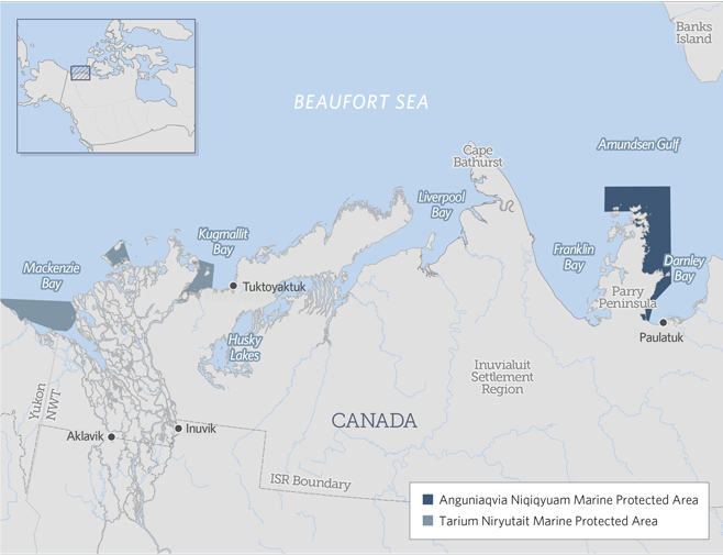
Environmental organizations and Inuvialuit leaders have praised the creation of a new marine protected area in the Canadian Arctic located around the west side of Darnley Bay near Paulatuk in the Inuvialuit settlement region of the Northwest Territories.
“This designation is an example of how governments and communities can work collaboratively, using both science and traditional knowledge to define meaningful boundaries and protections,” said Paul Crowley, the director of the World Wildlife Fund’s Arctic program in Canada.

The Pew Trusts’ Oceans North Canada is equally enthusiastic.
“The new area, together with the existing Tarium Niryutait Marine Protected Area in the nearby Mackenzie River estuary of the Beaufort Sea, will safeguard key summering habitat for about 28 percent, or close to 40,000, of the world’s belugas,” Oceans North said.
Called Anguniaqvia Niqiqyuam, the new marine protected area comprises 2,400 square kilometers (about 930 square miles) of ocean territory in the Beaufort Sea near Paulatuk, a small Inuvialuit community with a population of about 400 people.
It’s an area valued highly for its ecological resources: the only thick-billed murre bird colony in the Western Arctic, plus abundant stocks of Arctic char, cod, beluga, polar bears, and seals.
A federal government press release issued Nov. 16 says it’s “Canada’s first Marine Protected Area with conservation objectives based specifically on Indigenous traditional knowledge.”
At the same time, the Inuvialuit Regional Council wanted to ensure the protected area doesn’t hamper economic development opportunities.
“During consultations, the IRC expressed its support of the proposed marine protected area, though it noted that preserving economic development opportunities is equally important,” the federal government said this past June, when they published the regulations that give effect to the protected area.
To that end, the protected area’s boundaries are drawn to allow potential deep water harbour sites at two spots, Wise Bay and Summer’s Harbour, “which may be required to support future economic development opportunities in the region,” the federal government said.
Inland from Paulatuk, there’s a big geological anomaly that’s believed to contain large deposits of nickel and copper.
It lies on land for which the Inuvialuit hold surface and subsurface mineral rights, and the Inuvialuit have signed a concession agreement for those lands with a company called Darnley Bay Resources Ltd., which has been exploring the area.
But so far, it’s just a small project and the company is long way from establishing the existence of a viable resource.
All resource development, including seismic testing, and oil and gas exploration, is banned within the waters within Anguniaqvia Niqiqyuam’s boundary.
However, the ban on oil and gas exploration may be redundant, since Darnley Bay is believed to hold little potential for hydrocarbons.
Commercial fishing is banned, but Inuvialuit may continue to harvest fish in the area, and recreational fishing is also allowed.
Dredging is also allowed, to ensure that annual resupply vessels can continue to serve Paulatuk.
Many Inuvialuit organizations—including the Paulatuk Hunters and Trappers Committee, the Paulatuk Community Corp., the Inuvialuit Game Council and the IRC—collaborated with Ottawa in developing the new protected area.
“The commitment of the Inuvialuit to this Marine Protected Area reflects our culture and priorities to sustain the marine ecosystem,” IRC chair Duane Smith said.